
During sightseeing, how would you like to have an interactive map with cool places to see, specifically suited to your preferences? A map with location of your airport, bus, hotel, with gps capability and tailored information about stuff you really want to see? Like opening hours, recommendations from your friends and information for YOU.
Well, you have and it’s name is (no surprise there), evernote.
If you’ve read the “official” tips for travel planning with evernote you already know that you can:
- Use it for “cutting” pieces of information about tourist attractions
- Create packing checklist
- Share information with others using shared notebooks
- Use it for storing your itineraries
- Monitor your budget
That’s very helpful and I recomend you do all that, but that`s just childsplay.
Lets take it up a notch!
In my travel “workflow” (I know travel workflow seems like a chore, but its full of so mamy possibilities!) there are 3 stages:
- Beeing prepared.
- Travel planning
- Travel
Be prepared.
Internet is full o beautiful photos of awesome places. Personally, I like this one . Here are some examples (of course in Evernote 😛 )


You know that feeling that you get when you see a photo of some awesome place? That “OH DEAR GOD I WANNA GO THERE”? That happens to me too. But like it often is in the Internet, new thing comes along and we forget about it completely.
Here’s where evernote kicks in.
When I see a cool place, obviusly I make a note. But whats important, I also:
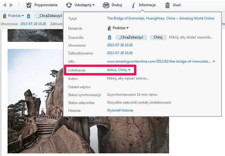
- Google the exact GPS coordinates of the place and input it in a note (notes have a “Location” field) :

Some tips: usually I find that place on google maps and use experimental feature called “Location marker” to get exact GPS data. - Tag it with “_IWannaSee” tag and continent / country tag (USA / South Africa / North Africa / Indonesia …)
- Save it in a special notebook
This ensures that when I’m going somewhere (or thinking about going) I can easily see on the map all the cool stuff that got ME excited (not some travel guide author). There`s nothing worse than to come back from a trip and learn that there was some cool stuff you didnt know about.

My map in evernote with locations of stuff I want to see
Travel planning.
Ok, so you’re going places. Awesome! I recommend you to:
- Make a notebook in evernote for your travel destination. Notebook, not tag because you can make notebook “offline” on your device (with evernote premium)
- Move all the notes you made in the “Be prepared” step that are located in the vicinity of your destination. Now you have some cool places to see, congrats!
- Google “places to see …” (your destination) and make the notes from the results. Also, input the EXACT gps coordinates in the location field (this is paramount)
- Buy some travel guides (lonelyplanet are good, but I prefer Eyewitness because of the nice sketches 🙂 ) and make photo-notes of the stuff you want to see. Also, input it in your evernote (I know its seems like over the top – you can carry your guide, but its very helpful to have everything in one place. )
- Ok, now you have everything in evernote and you can see the “map view”. See? You have an interactive map with every place you want to see. This is perfect because:
- You see which places are “grouping together” – and you can optimize of travelling between them
- Using your gps – enabled mobile device you can walk between them and it will be much easier to get there.
- You have all the notes (like opening times, tips, photos) right there on the map
- I dont recomend planning everything in advance. Leave a lot of room for adventure. But with an interactive map you know exactly where the cool stuff is. I like to wander in the vicinity of nice places but I dont want to walk around boring neighbourhods.
- To have an interactive map you need mobile device (well duh) and evernote premium. I use iPad and its perfect.
- Before travel you have to make sure that everything is copied on your device. Propably you wont have data, so you have to:
- Open ios maps, go to the vicinity of your destination, zoom the map and move around a litle. This will cache a map on your device.
- Mark a notebook with your places as offline in evernote. Then sync it – it will be copied to a device.
- Now turn of data & wifi on your device, go to map view and to your destination and be amazed how cool its working 🙂

Cool stuff to see in Tokio, from my trip to Japan (the flags are my notes)
- Apart from interactive map, I also:
- Make a packing checklist (I recommend TED talk: on the importance of checklists). In there I also have stuff like “arrange insurance”, and so on.
- Save all the travel documents, itineraries
- Save a scan of all my documents (passport, id, ). This makes sure that if I lose them, I still can present a copy

Showtime! (Travel)
And now basically all the hard work is done and you can enjoy.
Just take out your ipad / other device, open the map view, search for your location and see whats close. Map will lead you to the place and if you see something interesting on the way – dont be afraid to wander!
You will see something spectacular, I promise. And after, you will always know which direction to go.